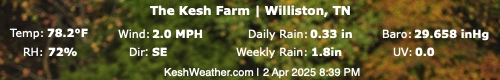
No Warnings, Watches, or Advisories

NWS South Mississippi Valley Regional Radar WU Central Satellite
Radar/Satellite images courtesy of NOAA/NWS and Weather Underground.
spacer
Updated: @ 05-May-2026 3:56am  
Summary / Temperature Wind Rain Outlook
Clear Clear
Currently: 60.6, Max: 62.4, Min: 59.7 60.6°F
Warmer 0.5°F than last hour.

Cool

Feels like: 61°F

24-hr difference
32°FWarmer 32.0°F than yesterday at this time.
  Today Yesterday
High: 62.4°F
12:00am
80.8°F
4:10pm
Low: 59.7°F
3:03am
53.6°F
2:34am
 Wind from ENE ENE
0.9
Gust:
6 mph
0 Bft - Calm
Today: 6 mph 3:43am
Gust Month: 17.9 mph May 04
Rain Today: 0 in
Rain Rate (/hr): 0 in
Rain Yesterday: 0 in
This Month: 0 in
Season Total: 12.28 in
Tuesday

Tuesday: Chance Showers And Thunderstorms
Chance Showers And T-Storms
Humidity & Barometer Almanac Moon
Humidity: 75 %  
Dew Point: 52.7°F Increased 0.5°F since last hour.
Barometer: 29.74 inHg Falling 0.01  inHg/hr
Baro Trend: Steady
Sunrise: 6:02am
Sunset: 7:46pm
Moonset: 8:22am
Moonrise: 11:51pm
Waning Gibbous
Waning Gibbous, Moon at 17 days in cycle
88%
Illuminated
UV Index Solar Radiation
   0.0    None
High: 0.0 @ 12:00am
0 W/m2 (0 %)
High: 0 @  12:00am
 NWS Weather Forecast  - Outlook: Overnight & Tuesday
Overnight

Overnight: Partly Cloudy
Partly Cloudy

Lo 59 °F
NWS forecast: Partly cloudy, with a low around 59. South wind around 10 mph. New rainfall amounts less than a tenth of an inch possible.
Davis VP+ forecast: Mostly cloudy and cooler. Precipitation likely. Windy with possible wind shift to the W, NW, or N.
 
Tuesday

Tuesday: Chance Showers And Thunderstorms
Chance Showers And T-Storms

Hi 76 °F
NWS forecast: A slight chance of rain showers before 7am, then a slight chance of showers and thunderstorms between 7am and 8am, then showers and thunderstorms between 8am and noon, then a chance of showers and thunderstorms. Mostly cloudy, with a high near 76. South wind 10 to 15 mph. Chance of precipitation is 80%. New rainfall amounts between a quarter and half of an inch possible.